Placing
the Panoramas in Context
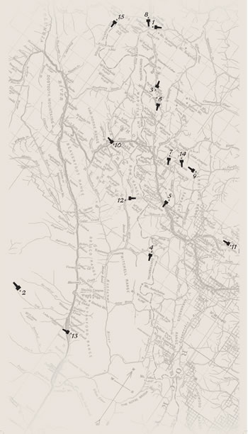
On
a detailed map of the region in which Charles Walcott discovered
the Burgess Shale, we have identified
the points
from
which selected
panoramas were taken. We have also identified the position
of the camera used by Walcott to take these unique photographs.
 In
the example to the right, the position where Walcott was standing
is indicated by the 'x', with the direction of the camera pointing
towards the narrow end. Therefore,
Walcott
took
this panorama of the eastern face of the Bow Range facing just
to the south of Vermillion Pass. In
the example to the right, the position where Walcott was standing
is indicated by the 'x', with the direction of the camera pointing
towards the narrow end. Therefore,
Walcott
took
this panorama of the eastern face of the Bow Range facing just
to the south of Vermillion Pass.
View
the Full Panoramas
Using the map to the left, click on a number/camera pairing to
view an image of the panorama that was taken in that location.
To view a full size image, click on the intermediate panorama
image. (Please note that the full size image may take some time
to download
to viewers on dial-up Internet connections.)
View
the Full Size Map
Click
here to view a full
size version of
this map (195K). You may navigate to the individual panoramas from
the full version as well. Just follow the
instructions outlined above.
About the Images
The images used in the map were digitally captured from full-size
direct copy negatives of the nitrate originals. Not all the prints
in the exhibition have matching negatives. The images are unretouched
and show defects that exist in the original nitrate negatives,
which are in cold storage. Because the negatives are so physically
large (up to 107 inches long) each was shot several times across
its length and the digital images were then stitched together.
The images were created by Smithsonian Photographic Services,
shot at 300 ppi resolution and saved as unmodified 16-bit greyscale
TIFFs. Image processing by SIA included inversion from negative
to positive, cropping and rotation, digital stitching, and derivitization
for use on the website.
View
a Topographic Image of the Area
GIS
technology enables you to see a topographical map of the area where
Charles D. Walcott discovered the Burgess Shale and collected Cambrian
fossils.
Click to here to view the GIS
map. |